
The Congo Basin is a vast region of Central Africa centred on the Congo River and its network of tributaries, forests and wetlands. It stretches across several countries and contains the world’s second-largest tropical rainforest, after the Amazon. Its location, extraordinary biodiversity and influence on the global climate have made it one of the most significant natural regions on Earth.

The basin is not a single country, national park or uninterrupted stretch of forest. It is a geographical area defined by the land from which water drains into the Congo River system. Rain that falls across this enormous watershed eventually flows through rivers and streams towards the Atlantic Ocean, connecting landscapes that cross national borders.
The region is primarily associated with the Democratic Republic of the Congo (DR Congo), which contains the largest share of the Congo rainforest. However, the wider basin extends into the Republic of the Congo, Cameroon, the Central African Republic, Gabon, Equatorial Guinea and parts of neighbouring countries, including Angola, Zambia, Burundi, Rwanda and Tanzania. The precise list of countries can vary depending on whether a source is referring to the hydrological basin, the rainforest or the broader Congo Basin conservation region.
At the heart of this landscape is the Congo River, one of the world’s great river systems. It flows through Central Africa before reaching the Atlantic Ocean and is widely recognised as the second-largest river in the world by discharge volume, after the Amazon. Its many tributaries carry water through dense forests, open wetlands, agricultural areas and settlements, sustaining communities and ecosystems across the region.
The basin’s geography is remarkably varied. Although the rainforest is its best-known feature, the region also includes swamp forests, seasonally flooded grasslands, savannahs and extensive peatlands. Some forest areas remain difficult to access, while towns, villages, roads and river routes connect people to markets and essential services. The Congo River itself has long served as an important transport corridor, particularly in areas where road infrastructure is limited.
The Congo rainforest covers a substantial part of the basin and is one of the most important tropical forest ecosystems in the world. Its trees absorb carbon dioxide as they grow, store carbon in vegetation and soils, and help regulate water movement through the landscape. The forest also releases moisture into the atmosphere, contributing to rainfall patterns across Central Africa and beyond.
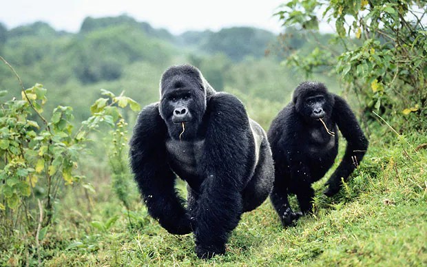
The Congo Basin is also home to an extraordinary range of wildlife. Gorillas, chimpanzees, bonobos, forest elephants and okapis inhabit its forests, alongside hundreds of mammal species, numerous birds and a remarkable variety of fish and other wildlife. Some species are found only in this part of the world, making the region particularly important for scientific research and conservation.
Its forests are not an empty wilderness. Millions of people live in and around the wider basin, relying on its rivers, forests and other natural resources for food, water, building materials, medicine and livelihoods. Indigenous peoples have longstanding cultural and practical relationships with these environments, drawing on detailed knowledge of forest plants, wildlife and seasonal changes. Any serious discussion of conservation in the region must account for the rights, needs and knowledge of the people who call it home.
One of the basin’s less visible features lies beneath the ground. Across parts of the Democratic Republic of the Congo and the Republic of the Congo, waterlogged peatlands contain enormous stores of carbon accumulated from partially decomposed plant material over long periods. The Central Congo Basin peatlands are recognised as the world’s largest continuous tropical peatland complex. Keeping these areas intact matters because draining or disturbing peat soils can release carbon that has remained stored for thousands of years.
Despite its scale, the Congo Basin faces mounting pressure from logging, agricultural expansion, mining, infrastructure development and hunting. These activities do not affect every part of the region equally, and the economic circumstances differ from one country to another. Forests provide resources and income for local communities, while governments face demands for jobs, transport, energy and development. The challenge is to meet those needs without destroying ecosystems whose value extends well beyond national borders.
Ash Dykes Heads Into the Congo Basin for a 700-Kilometre River Expedition
The basin’s geography helps explain why protecting it requires cooperation between countries. Rivers cross borders, wildlife moves between habitats, and changes in forest cover can affect water cycles and carbon storage across a much wider area. Conservation efforts in one country can be undermined if forests and habitats across the border are left exposed to similar pressures.
For anyone trying to locate the Congo Basin on a map, the simplest starting point is Central Africa, around the equator, with the Democratic Republic of the Congo at its centre. From there, the region extends into neighbouring countries through a connected system of rivers, forests and wetlands. It is both a physical landscape shaped by water and a living region shaped by people, wildlife and economic activity.
Understanding the Congo Basin means looking beyond the familiar image of a dense tropical forest. It is a vast river watershed, a home to millions of people, a refuge for exceptional wildlife and a storehouse of carbon. Its importance comes not from one landmark or one country, but from the connections between its forests, rivers, wetlands and communities.


